Conquering new frontiers in web mapping application development
A modern framework for developing custom GeoIT solutions
Open Pioneer Trails is an open development platform for web clients that enables the development of custom GeoIT solutions. The development platform is characterized by a lean and powerful runtime environment and modern development tools. It offers an excellent developer experience and a broad use of various interfaces (APIs). Development work can also be efficiently reused.
The Trails framework is available free of charge as open-source software on GitHub. This project is a collaboration between con terra and 52°North. It is part of the “Open Pioneer” initiative, which focuses on the collaborative development of modern technologies and components for the next generation of geodata infrastructures and solutions.
Trails is a framework — it does not provide a fixed solution or product. The development team provides many examples and basic application blueprints that serve as starting points for solutions.
The software is based on modern technologies:
- React (TypeScript)
- Chakra UI
- Vite
- pnpm
The Trails framework provides “core packages” that can be used to develop an application. These packages cover basic functionality such as logging, an internal event bus, theming and look and feel, native Chakra integration, i18n, and interaction with remote content using HTTP clients.

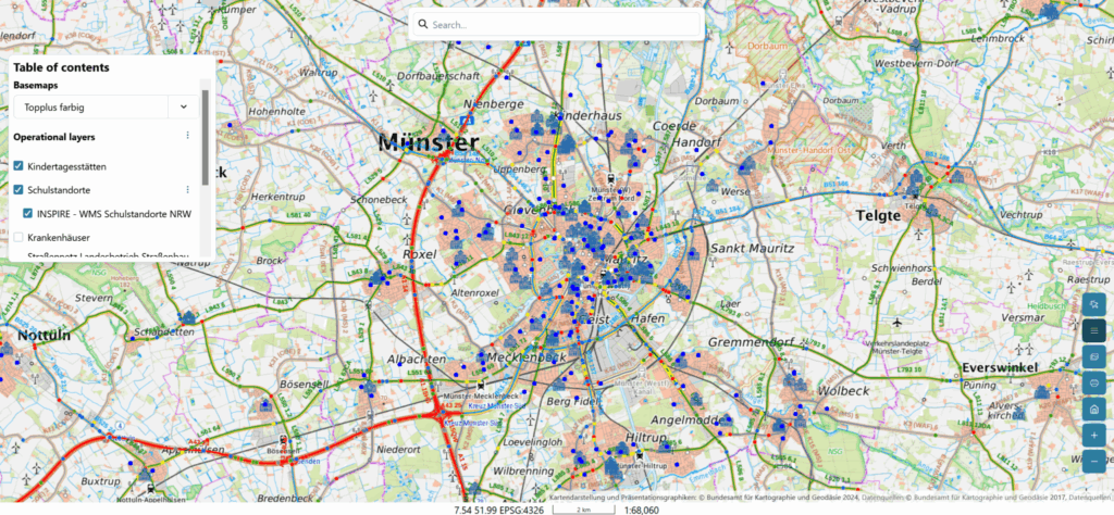
In addition to the core packages, Trails has a dedicated integration of OpenLayers for the development of Web GIS applications. The OpenLayers packages provide interfaces for map interactions, definition of map contents and a collection of reusable widgets and tools, such as:
- Base maps and switcher
- Interactions (pan, zoom, center)
- Table of Contents
- Coordinate display
- Scales
- Measurements
- Overview map
- Geolocation
52°North used the Trails framework as the techical basis to implement web mapping applications in several projects, including NFDI4Earth, Volkswagen GeoNet Analyzer, I-CISK, HISGIS or PEOPLE ECCO. These projects contributed to the evolution of Trails by providing new use cases as well as components and widgets to the community. Trails is a core technology at 52°North and is also currently used in multiple ongoing projects, e.g., the multi-year research project WebAIS.
con terra GmbH and 52°North maintain the Trails framework. The maintenance work includes improvements to the frameworkʼs API, updates of dependencies and the handling of pull requests from external projects. An example of improvements to the API is the integration of signals. Signals make it easy to monitor changing properties without complicated event handling. 2025 has seen the evolution of several technical aspects of Trails. Chakra UI, the underlying GUI library, has been updated to the most recent version 3. Our team also introduced the Reactivity API, which provides a sophisticated layer for managing the applications state. These changes emerged into the Trails framework major release version 4.0.
Benefits
By providing a modern framework and developer experience, Trails enables project and product teams to efficiently design web applications that meet the needs of modern spatial data infrastructures. Its flexibility allows many different use cases and interaction patterns to be addressed, while keeping the basic functionality in a central location.
Fields of Application
- Modern spatial data infrastructures
- Web mapping and web GIS
- Lightweight and embeddable mapping solutions
