Automated Workflows for Creating EO Products
Copernicus-based services for monitoring material inputs in watercourses and dams
The WaCoDiS project implemented a geoinformation infrastructure specifically optimized to account for water quality control, water protection and protection of access to clean drinking water for river basin management monitoring tasks. Using innovative and automated workflows, the consortium combines, merges and analyzes Earth Observation data from the Copernicus Program, weather data (i.e. from the German Weather Service, DWD) and in situ sensor data for monitoring water bodies. Interoperable services provide and cross-link input data, results, and the functionality developed in the project.
Based on a detailed analysis of user requirements as well as the technical and scientific status quo, the project members developed a WaCoDiS architecture and system design. Special consideration was given to the integration of potentially large Earth Observation data sets (i.e., from the Copernicus Program), the integration of cloud-based processing platforms (e.g., CODE-DE) and modern communication patterns ensuring the timely delivery of information.
Activities also covered the evaluation, preparation and persistence of appropriate Sentinel and DWD data, the development of automated analysis algorithms, and the implementation of interoperable data processing and access services. Complementary tasks addressed the adaptation and development of essential hydrological models.
In close collaboration with the Bochum University of Applied Sciences, 52°North supported the requirements analysis, developed the system architecture and implemented system components. Our team also evaluated different approaches to enable efficient processing of Copernicus data, interoperable provision of domain-specific processing and analysis models as well as new technologies for data sharing. We particularly focused on event-driven communication patterns in spatial data infrastructures and cloud-based data processing approaches. Complementary work comprised the contribution of results and experience gained during WaCoDiS to the international standardization process and the evaluation of recent and ongoing standardization activities regarding their relevance to WaCoDiS (e.g., OGC Publish/Subscribe standard, OGC SensorThings API).
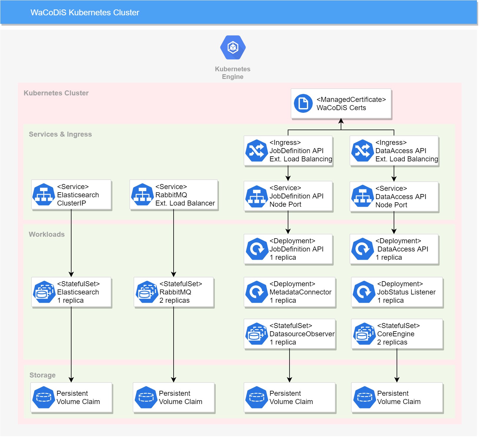
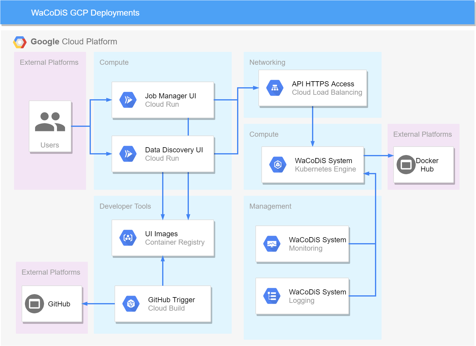
During the project’s final year, we focused on maturing the system and its components as well as evaluating different deployment strategies. The system successfully established the connection to the new CODE-DE platform, which was relaunched in April 2020. We deployed the algorithms for the data-related processing of Copernicus products as WPS instances in the CODE-DE cloud. In addition, our team successfully deployed the WaCoDiS system on the Google Cloud Platform (GCP), thus demonstrating its independence. We used different technologies (e.g., Google Kubernetes Engine, Cloud Run) to effectively set up the different UI and backend components. In close collaboration with the Wupperverband, 52°North evaluated the overall system based on selected test scenarios. We also demonstrated the WaCoDiS system to associated water management organizations as part of our outreach activities.
Project Partners
Coordinator: Bochum University of Applied Sciences, Germany
Wupperverband, Germany
Associate Partners
ITZBund (Informationstechnikzentrum Bund, Ilmenau), Germany
Netteverband, Germany
Niersverband, Germany