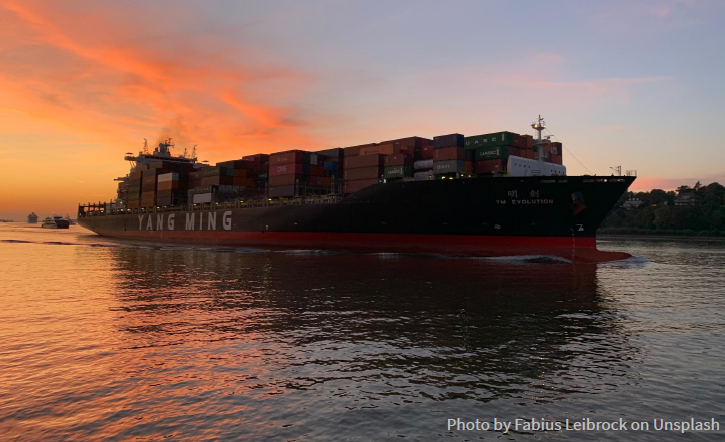
• Github
  • Wiki
  • News
  • Blog
  • Search

52°North Spatial Information Research GmbH

exploring horizons

  • 52°North Spatial Information Research GmbH

    exploring horizons

  • About us
    • Profile
    • Scientific & Technical Advisory Board
    • Shareholders
    • Affiliations
    • Contact us
  • Research
    • Scope
    • Associated Labs
    • Publications
  • Software
    • Software components
    • Licensing
    • Contribute
  • Services
  • Solutions
  • Outreach
  • Careers
Home > Archives forAnn Hitchcock

June 18, 2020

IJGI Special Issue: Geospatial Sensing 2020

IJGI Special Issue: Geospatial Sensing 2020

We are pleased to announce that there will be a special issue “Geospatial Sensing 2020 – from Sensing to Understanding Our World” to the International Journal of Geoinformation!

This special issue, along with our Geospatial Sensing | Virtual 2020, provides a platform for scientists, developers, and users to examine current challenges, present best practices, and discuss future developments on sharing, managing, discovering, analyzing, and visualizing geospatial sensor data. While selected presentations from the conference will be featured in this Special Issue, we invite anyone engaged in any work related to the theme of “Geospatial Sensing – from Sensing to Understanding our World” to submit a manuscript for publication.

Please note: This open access journal issue is dedicated but not limited to the selected papers of this conference.

More information…


June 9, 2020

CITRAM begins test phase

CITRAM begins test phase

Today’s virtual kick-off initiates the CITRAM – Citizen Science for Traffic Management research project’s testing phase. 

Hamm’s city administration employees are the first participants to test the CITRAM app. Today’s virtual kickoff informs the participants of the enviroCar driver fleet on the use of ODB (On-Board-Diagnose) adapters with the enviroCar and [ui] ECOMAT apps. Equipped with a car, an Android smart phone and an OBD adapter, the participants will anonymously track their driving along predefined routes for approximately 2 months.

The first fleet of cars will take to the streets on June 15, 2020. The cities of Krefeld (testing in Krefeld) and Chemnitz (testing in Chemnitz) will follow in the coming weeks. Testing should be completed by the end of August.

more >

June 2, 2020

mVIZ @ EGU20

mVIZ @ EGU20

Supporting Users to Find Appropriate Visualizations of Spatio-Temporal Open Data Sets

In order to facilitate efficient and user-friendly exploration of available data sets, it is essential to visualize the data as quickly and easily as possible. Selecting appropriate visualization approaches for potentially highly-dynamic spatio-temporal data sets is still a challenge. At the recent EGU2020: Sharing Geoscience Online, members of the mVIZ consortium introduced a methodology to support the selection and creation of user-friendly visualizations for data discoverable via the open data portals such as the mCLOUD.

Presentation…

More information about mVIZ…


May 27, 2020

Cos4Cloud @ EGU20

Cos4Cloud @ EGU20

Design and Development of Interoperable Cloud Sensor Services to Support Citizen Science Projects

Citizen Observatories are becoming an increasingly popular source of input data in many scientific domains. During the recent EGU2020: Sharing Geoscience Online, Simon Jirka (52°North) presented the ideas behind the European H2020 project Cos4Cloud (Co-designed citizen observatories for the EOS-Cloud). The project aims at providing re-usable services for setting up Citizen Observatories based on the European Open Science (EOS) Cloud. In particular, it will use interoperability standards such as the the Open Geospatial Consortium’s (OGC) Sensor Observation Service (SOS), SensorThings API and Observations and Measurements (O&M).

Presentation…

More information about the project…

  • « Previous Page
  • 1
  • …
  • 26
  • 27
  • 28
  • 29
  • 30
  • …
  • 47
  • Next Page »
  • News
  • Events
    • 52N Events
  • Careers
  • Contact Us
    • Legal Notice
  • Privacy Statement

Shareholders

  • con terra
  • esri inc
  • ifgiInstitute for Geoinformatics logo
  • itc
  • RSS
  • You Tube
  • Blueskybluesky logo
  • Fosstodon
  • LinkedIn

©2025 by 52°North Spatial Information Research GmbH. All Rights Reserved.